It was also known as Indus Valley Civilization (IVC). Harappan Civilization was of Indigenous origin which had gradually evolved. Initial communities of Mehrgarh etc. moved to fertile lands of Indus Valley. Surplus agriculture produce helped in development of other secondary activities. Gradually the population concentrated in the area leading to formation of Cities. Chalcolithic age helped in urbanization.
Geographical extent of Harappan or IVC was as follows:
In North- Manda in Jammu and Kashmir.
In South- Diamabad in Maharashtra.
In East- Alamgirpur in Uttar Pradesh.
In West- Sutkagendor in Pakistan.
Features of Harappan Civilization:
1. It was Indegenous.
2. It was urban and had urban institutions like citadel.
3. People were literate. Script was found however in could not deciphered yet.
4. It was an evolved society because means of entertainment like toys, chess, etc. found.
5. It was a multiclass society. There were artisans, merchants, traders, craftsmen etc.
6. It was also multiethnic society. There were proto australoids, dravidians and others.
7. No evidence of Iron. Familiar with Bronze.
8. There was uniformity in town planning, brick size, common standards for weights and measures. From this it can be inferred that there was presence of central administration.
9. Utilitarian outlook was there in buildings. Builidings were constructed as per the needs and were not much of architectural gradiose.
10. They have advanced water management system.
Political, Economical and Social life of Harappan civilization:
Political life:
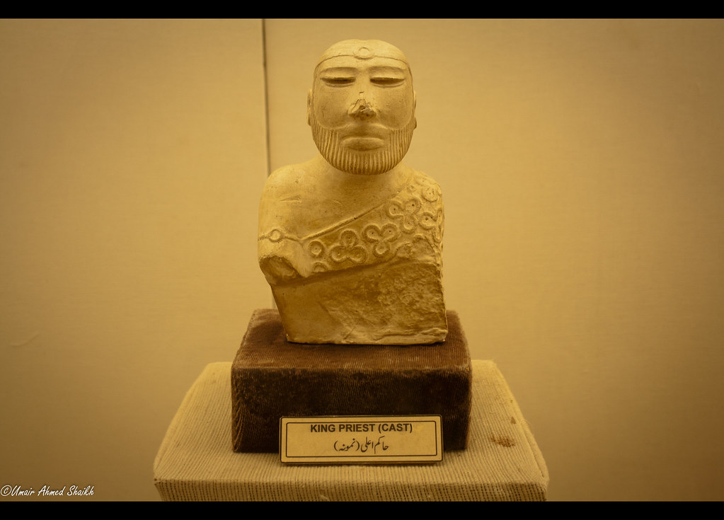
It might have been governed by some centralized authority as there was uniformity in town planning, brick sizes, weights and measures etc. Some believe that the state was ruled by priest-king. However, there is no clear evidence for the same.
Religious life:
The chief male deity was pashupati(Proto-shiva) who has three faces and two horns(figure given below). He was represented in seals found from the sites. He is surrounded by four animals (Tiger, Elephant, Rhino and Buffalo each facing different direction). Two deers are at the feet of proto shiva. The chief female deity was Mother Godess represented in teracotta figurines. In later times, linga worship was prevalent. Besides this, Harppan people also worshipped Trees and Animals. They also believed in ghosts and evil spirits and used amulets to protect from them.

Town planning:
The towns had a grid like pattern. All streets and lanes were cutting each other at right angles thus dividing the cities into rectangular blocks. The cities mainly divided into two parts- Citadel and Lower town. The Citadel was built on a podium made of mud bricks. On the lower part of the town houses were made where common people lived. Granaries were constructed to store surplus produce of agriculture. Most important construction found from Mohenjodaro was Great bath. It must have served as a site for ritual bathing.
Economic life:
There was great progress in all spheres of economic activities-agriculture, trade, industry and crafts. Surplus agriculture produce were stored in granaries. Trade flourished both -internal and external. Gold, Copper, tin, semi precious stones etc. were imported. Finished products like cotton goods, beads, jewelries, ivory products and agriculture products like wheat, barley, peas etc. were exported. It had trade relation with Mesopotamia, Afghanistan and Iran. Trade was barter type.
Social life:
Dress of both men and women included two pieces of cloth-one upper garment and other lower garment. Beads were worn by men and women. Jewelries were made of gold, silver, copper and semi precious stones. Cosmetics were is use. Children's toys include clay cart, marbles,ball and dice. Fishing was regular occupation. Hunting and bull-fighting were other past times.
Arts:
Figures of man, woman, animals and birds of teracotta and carvings on the seals show high degree of proficiency. Figure of dancing girl made of bronze found in Mohenjodaro shows remarkable workmanship. Pottery of Harappan was another specimen of fine arts. Pots and jars were painted with various colors and designs. Pictoral motifs included geometrical patterns like horizontal lines, circles, leaves, plants and trees.

Script:
The script has not been deciphered so far. The script was written from Right to left. In few seals boustrophedon technique of writing- writing in reverse direction in alternate lines was used.
Burial methods:
Complete burial and post-cremation burial were prevalent at Mohenjodaro. At Lothal burial pit was lined with bricks indicating the use of coffins. Wooden coffins were also found in Harappa. There is no clear evidence of practice of Sati.
Important sites of IVC:
Geographical extent of Harappan or IVC was as follows:
In North- Manda in Jammu and Kashmir.
In South- Diamabad in Maharashtra.
In East- Alamgirpur in Uttar Pradesh.
In West- Sutkagendor in Pakistan.
Features of Harappan Civilization:
1. It was Indegenous.
2. It was urban and had urban institutions like citadel.
3. People were literate. Script was found however in could not deciphered yet.
4. It was an evolved society because means of entertainment like toys, chess, etc. found.
5. It was a multiclass society. There were artisans, merchants, traders, craftsmen etc.
6. It was also multiethnic society. There were proto australoids, dravidians and others.
7. No evidence of Iron. Familiar with Bronze.
8. There was uniformity in town planning, brick size, common standards for weights and measures. From this it can be inferred that there was presence of central administration.
9. Utilitarian outlook was there in buildings. Builidings were constructed as per the needs and were not much of architectural gradiose.
10. They have advanced water management system.
Political, Economical and Social life of Harappan civilization:
Political life:
It might have been governed by some centralized authority as there was uniformity in town planning, brick sizes, weights and measures etc. Some believe that the state was ruled by priest-king. However, there is no clear evidence for the same.
Religious life:
The chief male deity was pashupati(Proto-shiva) who has three faces and two horns(figure given below). He was represented in seals found from the sites. He is surrounded by four animals (Tiger, Elephant, Rhino and Buffalo each facing different direction). Two deers are at the feet of proto shiva. The chief female deity was Mother Godess represented in teracotta figurines. In later times, linga worship was prevalent. Besides this, Harppan people also worshipped Trees and Animals. They also believed in ghosts and evil spirits and used amulets to protect from them.
Town planning:
The towns had a grid like pattern. All streets and lanes were cutting each other at right angles thus dividing the cities into rectangular blocks. The cities mainly divided into two parts- Citadel and Lower town. The Citadel was built on a podium made of mud bricks. On the lower part of the town houses were made where common people lived. Granaries were constructed to store surplus produce of agriculture. Most important construction found from Mohenjodaro was Great bath. It must have served as a site for ritual bathing.
Economic life:
There was great progress in all spheres of economic activities-agriculture, trade, industry and crafts. Surplus agriculture produce were stored in granaries. Trade flourished both -internal and external. Gold, Copper, tin, semi precious stones etc. were imported. Finished products like cotton goods, beads, jewelries, ivory products and agriculture products like wheat, barley, peas etc. were exported. It had trade relation with Mesopotamia, Afghanistan and Iran. Trade was barter type.
Social life:
Dress of both men and women included two pieces of cloth-one upper garment and other lower garment. Beads were worn by men and women. Jewelries were made of gold, silver, copper and semi precious stones. Cosmetics were is use. Children's toys include clay cart, marbles,ball and dice. Fishing was regular occupation. Hunting and bull-fighting were other past times.
Arts:
Figures of man, woman, animals and birds of teracotta and carvings on the seals show high degree of proficiency. Figure of dancing girl made of bronze found in Mohenjodaro shows remarkable workmanship. Pottery of Harappan was another specimen of fine arts. Pots and jars were painted with various colors and designs. Pictoral motifs included geometrical patterns like horizontal lines, circles, leaves, plants and trees.
Script:
The script has not been deciphered so far. The script was written from Right to left. In few seals boustrophedon technique of writing- writing in reverse direction in alternate lines was used.
Burial methods:
Complete burial and post-cremation burial were prevalent at Mohenjodaro. At Lothal burial pit was lined with bricks indicating the use of coffins. Wooden coffins were also found in Harappa. There is no clear evidence of practice of Sati.
Important sites of IVC:
Harappa
|
Excavated
by Daya Ram Sahni in 1921-1923.
Situated
on the bank of river Ravi in
Montgomery district of Punjab (Pakistan).
Stone dancing Natraja and Cemetry-37 have been excavated here.
|
Mohenjo-Daro (Mound of
Dead)
|
Excavated
by RD Bannerji in
1922.
Situated
on the Bank of river Indus in
Larkana district of Punjab (Pakistan).
Great Bath, Collegiate
Building and the Assembly Hall are the special features of the site.
Pashupati Mahadeva (Proto Shiva) seal and fragment of woven
cotton have been
excavated.
|
Chanhudaro (Sindh,
Pakistan)
|
Excavated
by NG Majumdarin
1931.
Situated
on the Bank of river Indus in
Sindh, Pakistan.
It
is only Indus Site with no Citadel.
Bronze figurines of bullock cart and ekkas and a small pot suggesting
a kink well have been excavated.
|
Lothal (Gujarat)
|
Excavated
by SR Rao in 1954.
Situated
on the bank of river Bhogava.
City
was divided into Citadel and the lower town and dockyard.
Evidence of rice has been found here.
|
Kalibanga (Black
Bangles), Rajasthan
|
Excavated
by BB Lal in 1961.
Situated
on the bank of river Ghaggar
Evidence
of ploughed field, wooden furrow, seven fire-altars, bones of camel and two types of burials (Circular
grave and rectangular grave) have been found.
|
Dholavira
|
Excavated
by JP Joshi in
1967-68
Situated
on the bank of river Luni of
Kachchh district in Gujarat.
Evidence
of unique water management system, Harappan inscription and stadium
has been found here.
|
Surkotada (Gujarat)
|
Excavated
by JP Joshi in
1972.
Situated
between the rivers Sabarmati and the Bhogava.
Evidence
of horse, oval grave and pit burial has been found here.
|
Banawali (Haryana)
|
Excavated
by RS Bisht in
1973.
Situated
on the bank of river Saraswati
Evidence
of both pre-Harappan and Harappan culture and barley with good quality has been found here.
|
Ropar
(Punjab)
|
Excavated by Y.D Sharma(1953)
Situated on bank of Sutlej
Evidence of Ware with
and without slip,black and red ware and ochre- coloured ware spouted vessels
and copper objects.
|
Rakhigarhi (Haryana)
|
Excavated by Suraj Bhan(1968)
|
Comments
Post a Comment