
Latitudes and Longitudes

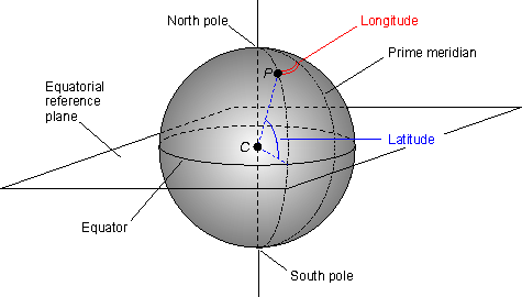
Latitudes and Longitudes are used for specifying location of a point on Earth's surface.
Latitudes are measured in respect of Equator. Equator itself is a latitude and is largest of all latitudes.  The length of latitudes keeps decreasing as we move from equator to poles. It ranges from 0 degrees to 90 degrees (North and South). The latitude of any point on earth's surface can be known by measuring the angle b/w the line joining that point with Center of earth and the Equatorial Plane.
Longitudes are measured in terms of Prime Meridian. Prime meridian is a longitude which passes through Greenwich, England and is assigned with 0 degree. Other Longitudes are measured with respect to it in East or West direction. It ranges from 0 degrees to 180 degrees (East or west). The longitude of a point on earth's surface can be known by measuring the angular distance b/w the longitude containing the point and the Prime Meridian. All longitudes are of equal lengths.


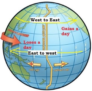
International Dated Line(IDL):

It is 180 degree longitude. As the earth rotates in west to east direction, places in eastern hemisphere will be ahead in time in r/o western hemisphere. For example, if it is 20/02/2018 in Eastern hemisphere, then it will be 19/02/2018 in western hemisphere. It means if someone crosses the International Date Line from East of IDL on 19/02/2018 to West of IDL he will lose one day i.e. he will reach West of IDL on 20/02/2018 and the day on 19/02/2018 will be skipped or lost. This can also be understood from the fact that it takes 24 hrs. for earth to complete one rotation along its axis. Which means if two points are at a distance of 360 degrees from one another there will be a difference of 24 hrs. b/w them. So, two nearby points on either side of International date line will experience a time difference of approx. 24 hrs b/w them.
Similarly, one day will be gained if someone moves from West of IDL to East of IDL.

Image result for International date line

Comments

Popular posts from this blog

Tribes in India(Tricks to remember Tribes in India)

1. Andhra Pradesh: Andh, Sadhu Andh, Bhagata, Bhil, Chenchus, Gadabas, Gond, Goundu, Jatapus, Kammara, Kattunayakan, Kolawar, Kolam, Konda, Manna Dhora, Pradhan, Rona, Savaras, Dabba Yerukula, Nakkala, Dhulia, Thoti, Sugalis.  Trick to remember: Andhere Pradesh mein ek Nayak ki jaroorat hai. Jackie Chen(chenchus) Nayak( Kattunayakan) hai. Wo ek village se Sugandha(sugalis)  ko Kundi (konda) todkar horse pe Savari kar k Bhaga(Bhagata)  le gya to Village k Pradhan ne War(kolwar) shuru kar di kyuki Jackie Chen dusri Jati (Jatapus) k hai. Raste mein Jackie Chen ko ek Andha Sadhu   Dhoti (Thoti) pehne hue Dhul  (dhulia) mein gira hua milta hai. Andhe Sadhu ki kamar(Kammara)  mein dard tha jiski wajah se wo RONe  (Rona) laga. Jackie Chen ne apne DABBe (Dabba Yerukula) mein se  Bhel Nikal( Bhil, Nakkal)  kar Sadhu ko  khane ko di. Badle mein Sadhu ne Jackie Chen ko ek Kalam  (Kolam) gift ki aur  Mann(Manna Dhora) mein dhanyawad dia aur GOD(Gond, Goundu) ki blessing di.

Interior of Earth

The Earth have following layers: 1. Crust 2. Mantle 3. Core Crust is the uppermost layer of the Earth. Its total thickness varies from 30-50 km. Its main constituents are Silicon and Aluminium and hence also called SIAL . There are 2 types of Crust- Continental and Oceanic. Continental Crust is thicker than Oceanic Crust. Thickness of Continental crust varies from 50-70 Km and that of Oceanic crust varies from 5-30 Km. Crust is further divided into Upper and Inner Crust. The discontinuity b/w Upper and Inner crust is known as Conard discontinuity. Below the Crust, the Mantle extends  to a depth of 2900 km. The main constituents of Mantle are Silicon and Magnesium and hence it is also called SIMA . It is further divided into Upper and lower mantle.  Together the Crust and upper part of Mantle which is in solid state, form ' Lithosphere '. Lithosphere floats over a highly viscous substance called Asthenosphere . Asthenosphere is main source of magma. The discontin

Geomorphology: Mountains

NOTE: Magma is molten rock below Earth's crust. Lava is magma that has reached the earth's surface. A mountain is a large landform that stretches above the surrounding land in a limited area, usually in the form of a peak. Types of mountains: 1. Fold Mountains: They are formed when two continental plates or one continental and one oceanic plate move towards each other at a convergent plate boundary. When the two plates collide the sedimentary deposits along the edges of Continental plates are forced to fold and hence folded mountains are formed. e.g. Himalyas. 2. Block mountains: They are formed due to faulting. They are not true mountains as they are formed by differential settlement of land mass. There is no actual upliftment taking place as in case of fold mountains. Middle part of any land mass gets  lowered resulting into relatively raising of adjoining landmasses or Lowering of landmasses on either sides resulting into relatively raising of middle landmass. B