Geo means earth, morpho means form, and logy means description. So Geomorphology is the study of earth, its landforms and various process, forces responsible for their formation. Based on the region of action these forces are classified into 2 types- Endogenetic and Exogenetic Forces.
1. Endogenetic forces act inside the Earth's crust. Objective of these forces is to create relief features on Earth's crust. It is further divided into Diastrophic and Sudden Forces.
Diastrophic forces act slowly and are of 2 types- Epeirogenic forces and Orogenic forces. Epeirogenic forces are related to Continent. They act in vertical direction. This causes upliftment or subsidence of continent.
Orogenic forces are related to mountains. They act in horizontal direction and can be tensile, compressive and shear. In Tensile forces plates move away from each other. In compressive forces plates move towards each other. In Shear forces plates slides past each other.
Sudden forces act suddenly. For e.g. Volcanoes and Earthquakes.
2. Exogenetic forces act outside Earth's Curst. They act through weathering, erosion and depositional processes. Agents of these forces are air, water, glaciers, sea waves etc. Two important factors which influence these forces are - temperature and precipitation. Due to these factors rocks on earth's surface undergoes process of weathering, erosion and deposition. Weathering is the decomposition of rocks, soil and their minerals through direct contact with earth's atmosphere. Erosion is the removal of rocks and soil from the surface. Glacier valleys, gullies etc. are some examples of landforms formed due to erosion. The difference b/w weathering and erosion is that weathering does not involve movement whereas erosion causes movement of the material to new location. The eroded material may get deposited to certain place. Landforms formed by deposition includes - sand bars, deltas etc.

Glacial valley
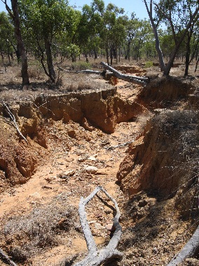
Gully

Delta
Comments
Post a Comment