
Geomorphology: Plateaus and plains

Plateaus:
Plateau is an extensive area of flat upland. They are storehouse of Mineral deposits. Based on their geographical location they are of following types:
1. Intermontane plateau: Partly or fully enclosed b/w mountain ranges. e.g. Tibetan plateau
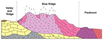
2. Piedmont plateau: Located on foot of mountain and locked on other side by either a plain on an ocean. They once had the height of mountain but reduced to mountain foot by erosion. e.g. Malwa plateau.
Image result for piedmont plateau example
3. Continental plateau: They are formed by continental upliftment or spread of lava sheet. e.g. Plateau of Maharashtra.
4. Volcanic plateau: They are formed by volcanic activity. e.g. Deccan trap
5. Dissected plateau: Their relief is sharp because of erosion.
Image result for dissected plateau example

Plains: 
They are the simplest landforms. They have a very gentle slope and minimum relief. They are most populated landforms. e.g. Indo-gangetic plains.
Image result for ganga plains

Comments

Popular posts from this blog

Tribes in India(Tricks to remember Tribes in India)

1. Andhra Pradesh: Andh, Sadhu Andh, Bhagata, Bhil, Chenchus, Gadabas, Gond, Goundu, Jatapus, Kammara, Kattunayakan, Kolawar, Kolam, Konda, Manna Dhora, Pradhan, Rona, Savaras, Dabba Yerukula, Nakkala, Dhulia, Thoti, Sugalis.  Trick to remember: Andhere Pradesh mein ek Nayak ki jaroorat hai. Jackie Chen(chenchus) Nayak( Kattunayakan) hai. Wo ek village se Sugandha(sugalis)  ko Kundi (konda) todkar horse pe Savari kar k Bhaga(Bhagata)  le gya to Village k Pradhan ne War(kolwar) shuru kar di kyuki Jackie Chen dusri Jati (Jatapus) k hai. Raste mein Jackie Chen ko ek Andha Sadhu   Dhoti (Thoti) pehne hue Dhul  (dhulia) mein gira hua milta hai. Andhe Sadhu ki kamar(Kammara)  mein dard tha jiski wajah se wo RONe  (Rona) laga. Jackie Chen ne apne DABBe (Dabba Yerukula) mein se  Bhel Nikal( Bhil, Nakkal)  kar Sadhu ko  khane ko di. Badle mein Sadhu ne Jackie Chen ko ek Kalam  (Kolam) gift ki aur  Mann(Manna Dhora) mein dhanyawad dia aur GOD(Gond, Goundu) ki blessing di.

Interior of Earth

The Earth have following layers: 1. Crust 2. Mantle 3. Core Crust is the uppermost layer of the Earth. Its total thickness varies from 30-50 km. Its main constituents are Silicon and Aluminium and hence also called SIAL . There are 2 types of Crust- Continental and Oceanic. Continental Crust is thicker than Oceanic Crust. Thickness of Continental crust varies from 50-70 Km and that of Oceanic crust varies from 5-30 Km. Crust is further divided into Upper and Inner Crust. The discontinuity b/w Upper and Inner crust is known as Conard discontinuity. Below the Crust, the Mantle extends  to a depth of 2900 km. The main constituents of Mantle are Silicon and Magnesium and hence it is also called SIMA . It is further divided into Upper and lower mantle.  Together the Crust and upper part of Mantle which is in solid state, form ' Lithosphere '. Lithosphere floats over a highly viscous substance called Asthenosphere . Asthenosphere is main source of magma. The discontin

Geomorphology: Mountains

NOTE: Magma is molten rock below Earth's crust. Lava is magma that has reached the earth's surface. A mountain is a large landform that stretches above the surrounding land in a limited area, usually in the form of a peak. Types of mountains: 1. Fold Mountains: They are formed when two continental plates or one continental and one oceanic plate move towards each other at a convergent plate boundary. When the two plates collide the sedimentary deposits along the edges of Continental plates are forced to fold and hence folded mountains are formed. e.g. Himalyas. 2. Block mountains: They are formed due to faulting. They are not true mountains as they are formed by differential settlement of land mass. There is no actual upliftment taking place as in case of fold mountains. Middle part of any land mass gets  lowered resulting into relatively raising of adjoining landmasses or Lowering of landmasses on either sides resulting into relatively raising of middle landmass. B